Chapter 3: Waterford City & MASP
|
Strategic Objectives |
|---|
|
Plan for and deliver a future for Waterford City as envisaged in the NPF, Waterford PLUTS and Waterford City MASP (RSES) where Waterford fulfils its role as the Regional City and home to the South East Technological University. |
| As a leading member of the MASP implementation body, in collaboration with the Southern Regional Assembly, Kilkenny County Council, State and other agencies/ stakeholders, we will implement the priorities and objectives of the Waterford MASP to support the critical mass required for Waterford City to function as a regional city of scale in support of the broader south east region. |
| We will identify investment priorities to deliver the concentric city model founded on the principle of transport-orientated and infrastructure led development |
3.0 Waterford City: The NPF, RSES and MASP
Waterford City is a key asset for Ireland in terms of its location, ability to compete nationally and internationally and capacity to grow and to relieve pressure on Dublin and surrounding counties. The National Planning Framework recognises Waterford’s role and potential as a national centre of scale to complement Dublin based on population and job creation supported by the South East Technological University (SETU). The targeted growth of Waterford, providing an additional c. 12,000 jobs to support and additional 27,000 – 32,000 population by 2040, is vital to the national and regional long-term growth strategy expressed in the NPF.
The principles which underpin the sustainable development of Waterford City as the south-east regional city of scale with associated economic and community are set out in the NPF. The NPF recognises that the key challenge for Waterford is to build scale and enhance urban quality through employment led growth. Opportunities exist to build on the City’s existing employment base which includes pharma, med-tech and engineering/advanced manufacturing sectors, as well as emerging indigenous enterprises while enhancing Waterford’s boutique-city attractiveness, quality of life and access thereto. Waterford also offers opportunities as a location for new University expansion and support functions in areas such as financial or professional services that may wish to avoid larger urban areas. It is also an emerging tourist centre, located on the route from Rosslare to Cork and the South-West and as a destination for cruise traffic.
The NPF proposes a series of key future growth enablers which have been further developed into a number of key themes and derived guiding principles and policies in the RSES MASP. The five principle themes include:
- Integrated Land Use and Transportation to deliver investment and the concentric city.
- Housing and Regeneration across the city and its diverse neighbourhoods to achieve compact, infrastructure led growth.
- Employment and Enterprise to bring about transformational change.
- Natural Environment to support the recreational needs of the expanding population while protecting and enhancing biodiversity; and,
- Social Infrastructure of a standard to support communities and advance the learning city and county and associated social and economic development.
To give effect to the guiding themes of the NPF which will enable Waterford City to fulfil its regional and national role, the following Key Future Growth Enablers for Waterford city and MASP are set out in the NPF & RSES:
- Delivering the North Quays SDZ regeneration project including a new pedestrian/public transport bridge over the River Suir.
- Identifying infill and regeneration opportunities to intensify housing and employment development throughout city centre and inner suburban areas.
- Enabling enhanced opportunities for existing communities as development and diversification occurs, particularly through employment, learning and education support.
- Progressing the sustainable development of new greenfield areas for housing and the development of supporting public transport and infrastructure.
- Public realm and urban amenity projects, focused on streets and public spaces, particularly in the city centre and inner urban area in support of urban intensification.
- The development and expansion of the SETU as part of the wider Multi Campus Technological University and integration with the City and region.
-
Provision of Citywide public transport and strategic cycleway networks.
- Extension of the Waterford Greenway to link SETU to the City Centre.
- Enhanced regional connectivity through improved average journey times by road to Cork, Limerick and ports within the region.
- Ensuring that water supply and waste-water needs are met by new national projects to enhance Waterford’s water supply and increase wastewater treatment capacity.
- Improving sustainability in terms of energy, waste management and resource efficiency and water, to include district heating and water conservation.
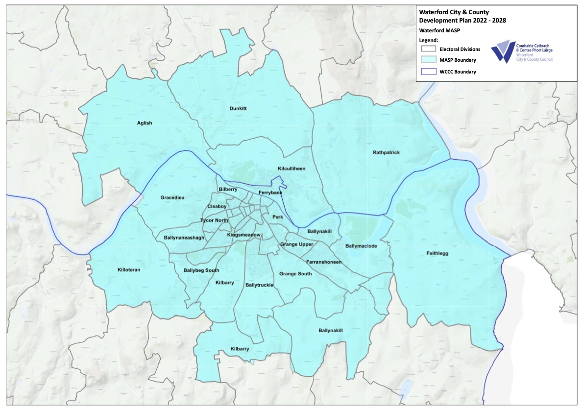 Figure 3.1 Waterford MASP (Source RSES)
The Development Plan and core strategy will give support through relevant policy objectives to enable the delivery of the key growth enablers and the transformational change required across Waterford City as envisaged in the NPF, RSES and MASP. We will implement the NPF, RSES and MASP through the Development Plan strategies and policy objectives over the period to 2028 and pursue specific project investment through the National Development Plan, the Urban Regeneration Development Fund and other available funding mechanisms.
3.1 Integrated Land Use and Transport PLUTS & WMATS
The concept of integrated land use and transport planning for the city is set out in the Waterford Planning Land Use and Transport Strategy (PLUTS) 2004 – 2020 (Figure 3.2). Important infrastructure has been delivered such as the M9 Waterford to Dublin and Bridge Crossing, the improved N25 and National Port access road (N29) required to support the PLUTS adopted population scenario and growth strategy[1]. However, the key element of the PLUTS including the population increase and the delivery of a “concentric city model” has not significantly progressed.
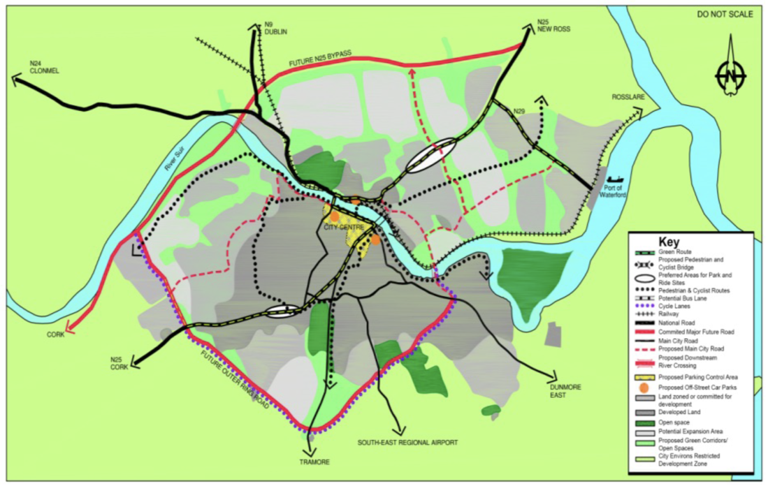
Figure 3.2 Concentric City (Source PLUTS)
To provide a new focus to deliver the concentric model and population targets, the RSES and Waterford MASP have incorporated the guiding principles of the Waterford PLUTS and in this regard Section 6 of MASP and MASP Policy Objectives 5, 6 and 7 relate to integrated land use and transport, sustainable mobility and regional connectivity along with the transport infrastructure required to deliver the concentric city of scale within the context of reduced emissions and a just transition to a low carbon society. High quality infrastructure of note includes:
- Relocation of the Railway Station located on the North Quays with more direct access to city centre.
- Improved connectivity between the city centre and the North Quays and wider Ferrybank area including provision of a pedestrian/public transport bridge.
- Provision of an additional Downstream Crossing to provide a link to the south bank of the River Suir in the vicinity of Maypark or Ardkeen, which would serve to create greater connectivity between lands to the North and South of the Suir, improve access to University Hospital Waterford and ease congestion on Rice Bridge;
- New Link Road from Abbey Road to Belmont to improve sustainable connectivity.
- Enhancement of regional connectivity on the N24, N25, enhanced rail infrastructure and services and strategic links to Rosslare Europort.
- Development of a comprehensive Metropolitan Area Public Transport system (bus network) including routes from the City Centre to SETU, Waterford University Hospital, Port of Waterford at Belview and from nearby towns including Tramore.
- Development of sustainable travel options to support and facilitate improved access to the City Centre, from the wider urban area, north and south of the river by walking, cycling and public transport including provision for Park and Ride facilities in tandem with the Green Route, additional cycle lanes;
- Quick, frequent and convenient bus services in the City.
- Development of new sustainable travel routes including greenways & blueways.
- Development of a more Walkable City.
- Support traffic calming measures to make the Metropolitan Area such as shared streets and pedestrian friendly environments with wider footpaths, identification of walking routes with improved signage, creation of places and spaces to meet and rest, street tree planting.
- Demand management measures to encourage modal shift to bus and rail for commuters into the city from surrounding towns; and,
- The preparation of a Waterford Metropolitan Area Transport Strategy, along with Area Based Transport Assessments.
The National Transport Agency (NTA), in conjunction with Waterford City and County Council and Kilkenny County Council have developed the Waterford Metropolitan Transport Strategy (WMATS). WMATS has informed the Development Plan in terms of the broader land use and transportation planning and demand management measures for the City over the life of the NPF while a review of PLUTS can also be undertaken once WMATS has been adopted.
3.2 Waterford City Supplementary Core Strategy
The Core Strategy underpinning the unitary Development Plan is set out in Chapter 2 Part 1 of Volume 1 of the Plan. The following supplementary core strategy identifies the population targets applicable to the MASP (Table 3.1), the strategic residential locations in Waterford City (Figure 3.3) and the potential regeneration sites (Table 3.2) which may be developed during the life of the Development Plan.
The supplemental core strategy identifies that while the total population for the entire MASP area (including urban and rural areas in County Kilkenny) remains consistent with the RSES, there is a move towards achieving the concentric city at a pace greater than that envisaged in the RSES.
|
Table 3.1 Waterford City and MASP Population Targets |
||||
|---|---|---|---|---|
|
2016 |
2026 |
2028 |
2031 |
|
|
Waterford County |
116,162 |
135,000 |
137,630 |
144,000 |
|
Metro Area Total (inc Kilkenny) |
59,854 |
74,464 |
77,386 |
81,769 |
|
Waterford City & Suburbs |
48,216 |
60,716 |
62,382 |
66,966 |
|
Waterford Rural |
3,399 |
3,819 |
3,903 |
4,029 |
|
Waterford County |
51,615 |
64,535 |
66,258 |
70,995 |
|
Waterford City & Suburbs |
53,504 |
67,324 |
70,088 |
74,234 |
The RSES recognises that the provision of adequate residential accommodation for different housing needs and household sizes will require the identification of housing needs through housing strategies and identification and prioritisation of strategic housing locations. The following lands have been identified in the RSES for the purposes of building resilience across our existing and emerging neighbourhoods:
- City South West Neighbourhood: Kilbarry (LIHAF location) which will create a potential for 450 new housing units by 2021.
- City North West Neighbourhood: Carrickphierish (LIHAF location) with a potential for 200 new housing units by 2021.
- Development of lands zoned for residential development in Ferrybank for c 850 units.
In terms of such greenfield areas located within the built footprint of the city, we will promote and support consolidation of in two principle neighbourhoods i.e. City South West Neighbourhood (University/ Ballybeg/ Kilbarry/ Lacken), and City North West Neighbourhood (Carrickphierish to 2028 while a local area plan will be put in place for Gracedieu prior to the next Development Plan cycle). We will collaborate closely with Kilkenny County Council to implement the development of lands in Ferrybank consistent with the RSES. The development of the City South West beyond the potential housing units envisaged in the RSES to 2021 will be possible over the period of the Development Plan given the extent of new service infrastructure to facilitate growth, it is likely that City North West will offer some scope to deliver housing units beyond the 200 units envisaged in the RSES and this will take place along the spine of the Carrickphierish Road, focussed around what has been identified heretofore in City Development Plans as Neighbourhood One.
The delivery of regeneration lands as identified in the RSES and other regeneration sites set out hereunder to the housing market will be pursued over the lifetime of the Development Plan by way of active land management and collaboration with state agencies such as the LDA and land owners. It terms of the Core Strategy it must be recognised however that given the landownership, scale, location and service context of these sites it will be difficult to provide a schedule or timeframe as to when the development of residential units will be achieved. The regeneration lands also hold the potential to provide additional accommodation for commercial and employment uses, particularly those located in predominantly housing areas and as such the potential housing yield figures should be treated as indicative only.
In order to fully support the provisions of the Urban Development and Building Heights Guidelines for Planning Authorities (2018), the Development Plan has adopted a proactive and flexible approach to securing compact regenerative urban growth through a combination of facilitating increased densities and building heights, while also being mindful of the quality of development and balancing amenity and environmental considerations. Where substantial regeneration capacity is available on any one site it will also be important to ensure that consideration is given to the provision of an appropriate mix of residential, commercial and employment uses, especially where block delivery sequencing can facilitate this form of balanced and resilient urban regeneration which supports urban communities.
Table 3.2 includes potential regeneration sites while also identifying the relevant sites which may be suitable for higher densities and taller buildings based on the following criteria:
- The provisions of WMATS and proximity to significant public transport infrastructure and/or trip generators.
- Site size and location relative to the city centre/neighbourhood/district centre.
- Proximity and orientation of the proposed site with regard to neighbouring land uses and the nature of the neighbouring use; and,
- Capacity to enhance amenity and placemaking at any location.
|
Table 3. 2 Waterford City Pote ntial Regeneration Sites |
||||
|---|---|---|---|---|
|
Ref No |
Site Location |
Site Area (Ha) |
Issues to Note |
Potential Taller Buildings/ Higher Density[2] |
|
OPS01 |
Saint Joseph's House Manor Hill |
2.46 |
n/a |
|
|
OPS02 |
Exchange Street Site |
0.18 |
n/a |
|
|
OPS03 |
Thomas Hill |
0.21 |
n/a |
|
|
OPS04 |
Jenkins Lane |
0.48 |
Site assembly |
|
|
OPS05 |
North Quays SDZ |
11.72 |
Provision of enabling infrastructure |
|
|
OPS06 |
Former Waterford Stanley Site, Bilberry |
5.05 |
n/a |
|
|
OPS07 |
John’s College, The Folly |
5.21 |
Trees of amenity value to be retained and reuse of protected structures |
|
|
OPS08 |
St Otteran’s, John’s Hill |
15.61 |
Reuse of protected structures |
|
|
OPS09 |
Former Brooks Site, Newtown Road |
1.53 |
Site assembly |
|
|
OPS10 |
Glenville (Former Power Seeds) Dunmore Road |
0.89 |
n/a |
|
|
OPS11 |
Kilbarry |
8.31 |
Site assembly and new access provision |
|
|
OPS12 |
Former Waterford Crystal Site |
14.96 |
Student accommodation, mixed commercial use /educational uses |
|
|
OPS13 |
Gasworks Site/Johnstown Business Park |
2.89 |
n/a |
|
|
OPS14 |
Dock Road |
1.85 |
Displacement of existing use |
|
|
OPS15 |
Industrial land at Cleaboy/Keanes Road/ Skibereen Roads |
8.15 |
Site clearance and displacement of existing use |
|
|
OPS16 |
Tycor industrial complex |
1.63 |
Displacement of existing land uses |
|
|
OPS17 |
Former Ard Ri Hotel |
7.75 |
Access and topography |
|
|
OPS18 |
Tesco Ardkeen |
1.28 |
Retaining adequate car parking |
|
|
OPS19 |
South Quays |
2.62 |
Preparation of design framework |
|
|
OPS20 |
Spring Garden Alley |
0.09 |
Site assembly |
|
|
OPS21 |
Bolton Street |
0.72 |
n/a |
|
|
OPS22 |
Former Waterford Crystal Sports Campus |
9.88 |
n/a |
|
|
OPS23 |
Williamstown/ Outer Ring Road |
13.12 |
n/a |
|
|
OPS24 |
Neighbourhood Centre Carrickphierish |
7.29 |
n/a |
|
|
OPS25 |
District Centre Tramore Road |
1.32 |
Retaining adequate car parking |
|
|
OPS26 |
O’Byrne’s Garage, The Glen |
0.10 |
n/a |
|
|
OPS27 |
Michael Street |
1.42 |
n/a |
|
|
OPS28 |
Ballybricken |
0.75 |
Site assembly |
|
|
OPS29 |
Lisduggan Shopping Centre |
0.82 |
n/a |
|
|
OPS30 |
The Glen |
0.19 |
Site assembly |
|
While the supplemental core strategy identifies the framework for the new spatial expression of Waterford moving towards the concentric city, the pace and sequence of how this development takes form will be dependent of a significant number of issues, in particular land ownership and release of lands to market. We will collaborate closely with landowners and developers to pursue the objectives of the core strategy, in a manner that implements the place making strategy and housing strategy of the Development Plan, and supports the role of Waterford City as an international location of scale, and a primary driver of economic and population growth in the Southern Region.
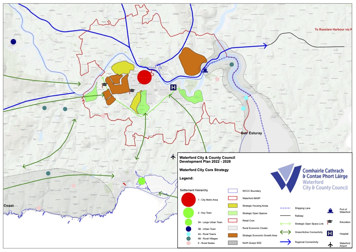
Figure 3.3 Waterford City Core Strategy Map
3.3 The Neighbourhood Strategy
An essential element of a sustainable development strategy as outlined in the PLUTS, NPF and RSES is the development of a compact city, which is characterised by the consolidation of existing neighbourhoods and the establishment of new neighbourhoods. The neighbourhood strategy acknowledges and reinforces the city centre as the core of the city; a place for work, shopping, services, leisure and living, supported by a series of neighbourhoods focused on neighbourhood centres. The Guidelines for Planning Authorities on Sustainable Residential Development in Urban Areas, DoEHLG, 2009 identifies criteria on planning for sustainable neighbourhoods under four main themes: provision of community facilities, efficient use of resources, amenity/quality of life issues and conservation of the built and natural environment. These are further developed in Section 6 of the NPF, Section 3 and Appendix 3 of the RSES and Chapters 7 and 8 of this Development Plan.
For vibrant communities to emerge in developing neighbourhoods people must connect and develop social networks, forming an association with where they live. Thus, the challenge is to provide healthy, vibrant, sustainable neighbourhoods through the provision of social and cultural neighbourhood facilities in tandem with economic and commercial infrastructure.
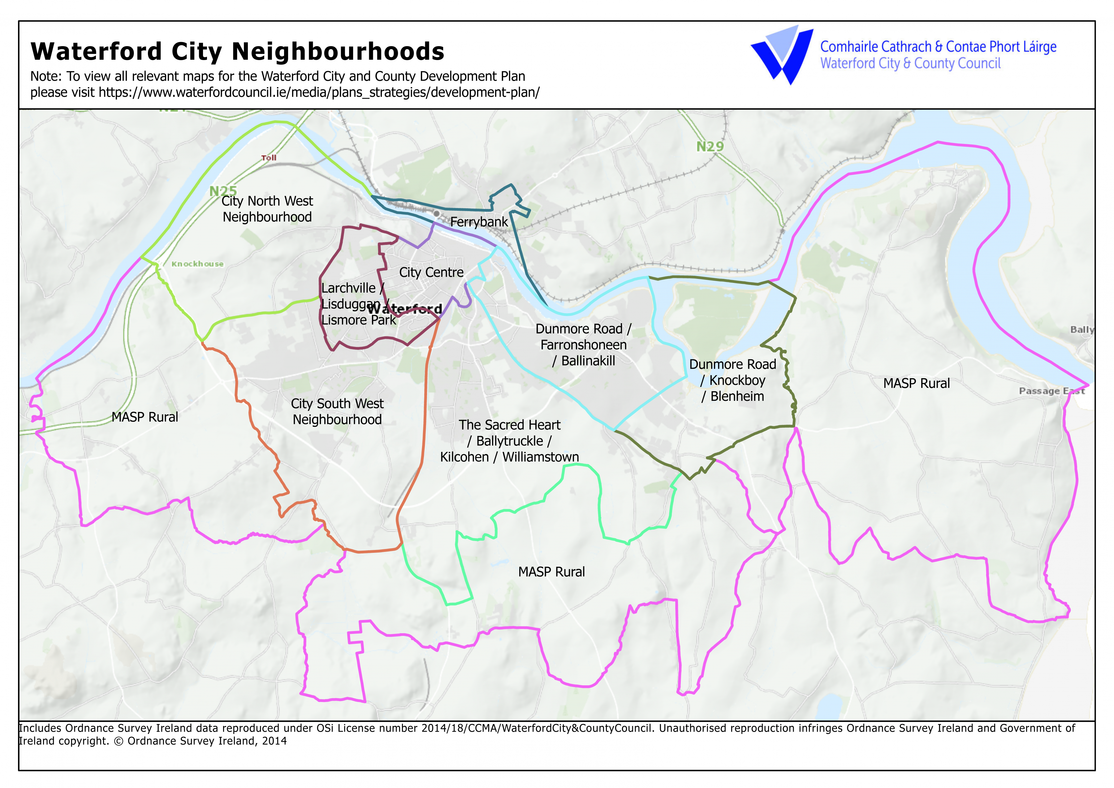
Figure 3.4 Waterford City Neighbourhoods
The focus of the neighbourhood strategy is on concentrating development around neighbourhood centres, providing additional community services and facilities and, in the already developed areas, local regeneration and retrofitting of amenity and sustainable mobility corridors. Neighbourhood centres contain a mix of uses including housing, retail, employment, education and community services. Each neighbourhood centre should be linked to the surrounding residential areas by a
system of cycleways, footpaths and a hierarchical and coherent road network. The neighbourhood centres should be linked to the City Centre, and to other neighbourhood centres, by improved and developing public transport under the guidance of WMATS and associated demand management measures.
There is a need to ensure that the various qualities of the developed neighbourhood areas are protected and improved and that the neighbourhood/district commercial centres serving these areas are reinforced and strengthened as necessary.
The Neighbourhood Structure consists of the following six neighbourhoods, the boundaries of which are undefined and overlap:
- City North West Neighbourhood including Carrickphierish and Gracedieu
- City South West Neighbourhood including Kilbarry, Ballybeg and SETU
- The Sacred Heart – Ballytruckle / Kilcohan
- Dunmore Road – Knockboy / Blenheim & Farronshoneen / Ballinakill
- Larchville / Lisduggan / Lismore
- Ferrybank
It is also recognised that there are other areas within the City with distinct identities which function as neighbourhoods, as distinct from the planning concept, meaning of the term. Examples would include Ballybricken and the "upper town" area, city centre, Newtown and Poleberry. Such areas form part of the existing fabric and character of the city and infill development in these areas will be required to generally conform to the essential characteristics of the locality. In addition, we will seek opportunities to provide for appropriate additional community services, amenities and facilities in such areas.
3.3.1 City North West Neighbourhood including Carrickphierish and Gracedieu
The Waterford City Council Action Plan for the North-West Suburbs was prepared in 1999 and provided for the phased establishment of two distinct new neighbourhoods, Neighbourhood One, Carrickphierish and Neighbourhood Two, Gracedieu, each having a range of facilities at its centre with residential areas within easy walking distance. In 2005 elements of the Action Plan were reviewed. Based on location, topography and service availability it was envisaged that Carrickphierish would develop out before Gracedieu became available for development and would be the centre and focus of the North West Suburbs, with a larger neighbourhood including a local shopping centre, schools, community and recreational facilities. Gracedieu could then develop following the achievement of critical mass of sustainable development in Carrickphierish and in accordance with a detailed framework plan which was to be prepared prior to Gracedieu opening up for development.
Given the passage of time since the Action Area Plan was first made, the extent of remaining undeveloped lands in Neighbourhood One, the infrastructure required and the broad transport and infrastructure strategies to be prepared following the making of the Development Plan, it is proposed to carry out a detailed strategic assessment of the opportunities and constraints to completing Neighbourhood One and developing out Neighbourhood Two, and prepare a Local Area Plan to facilitate a statutory approach to the detailed planning requirements for the area. Development of Neighbourhood Two prior to the preparation of the LAP and the provision of critical infrastructure will therefore be inappropriate. This is reflected further in the land use zoning objectives for the area.
|
City North West Neighbourhood Policy Objectives |
|
|---|---|
|
W City 01 |
During the life of the Development Plan we will prepare a strategic framework plan, area-based transport assessment and Local Area Plan to guide the sustainable development of Neighbourhood Two at Gracedieu prior to the release of land in this area for development. |
|
W City 02 |
When considering development proposals in remaining undeveloped areas of Neighbourhood One, we will ensure that full consideration is given to the retention of options for accessing Neighbourhood Two. |
|
W City 03 |
As opportunities arise, we will ensure permeability sustainable mobility links are developed between the Schools/ Public Library and the IDA Northern Extension. |
|
W City 04 |
We will provide traffic calming along Carrickphierish Road in order to assist in creating enhanced sense of place between the Schools/Public Library and the neighbourhood centre and improve the safety of the road for active travel modes. |
3.3.2 City South West Neighbourhood including Kilbarry, Ballybeg and SETU
This neighbourhood has been identified as a strategic neighbourhood with potential for growth, located in close proximity to SETU, the I.D.A. Industrial Estate, the Regional Sports Centre, Waterford Nature Park and the Outer Ring Road. Residential expansion has continued to some extent during the recent economic downturn and has increased steadily in more recent years around Foxwood, Carriginard and along the newly developed LIHAF road. More importantly the development of this road and associated service infrastructure has resulted in the removal of infrastructural constraints to the development of the lands in Kilbarry for the period of this Development Plan.
Waterford City and County Council has developed a draft design framework for the City South West Neighbourhood. Some of the spatial elements of this are set out in Figure 3.4 along with a preferred neighbourhood layout and Masterplan for lands now accessible via the new LIHAF road. Further details of the design framework can be found in Appendix 6. It is envisaged that Kilbarry will be the focus of the next neighbourhood in the city which will be guided further by WMATS, subsequent area-based transport assessment and local area planning.
The area adjoins Kilbarry Park, Waterford Nature Park and the Tramore Road to the east however direct access to Kilbarry Park and the Nature Park is not currently available from the neighbourhood. Further opportunities to effectively pull Kilbarry Park into the development of further public open space in Kilbarry and along the Cork Road while linking this further into the broader active transport network of cycleways and walkways with links to the outer ring road.
South East Technological University campus and the former Waterford Crystal site form the western boundary of the neighbourhood along the Cork Road. The development of this portion of the city neighbourhood for educational/enterprise and ancillary development and purposes of the SETU will support the strategic policy objectives of the RSES and MASP.
There is an opportunity to develop the link road between Tesco and the existing neighbourhood centre as a new focus for the neighbourhood centre to include for housing, education, community and commercial development.
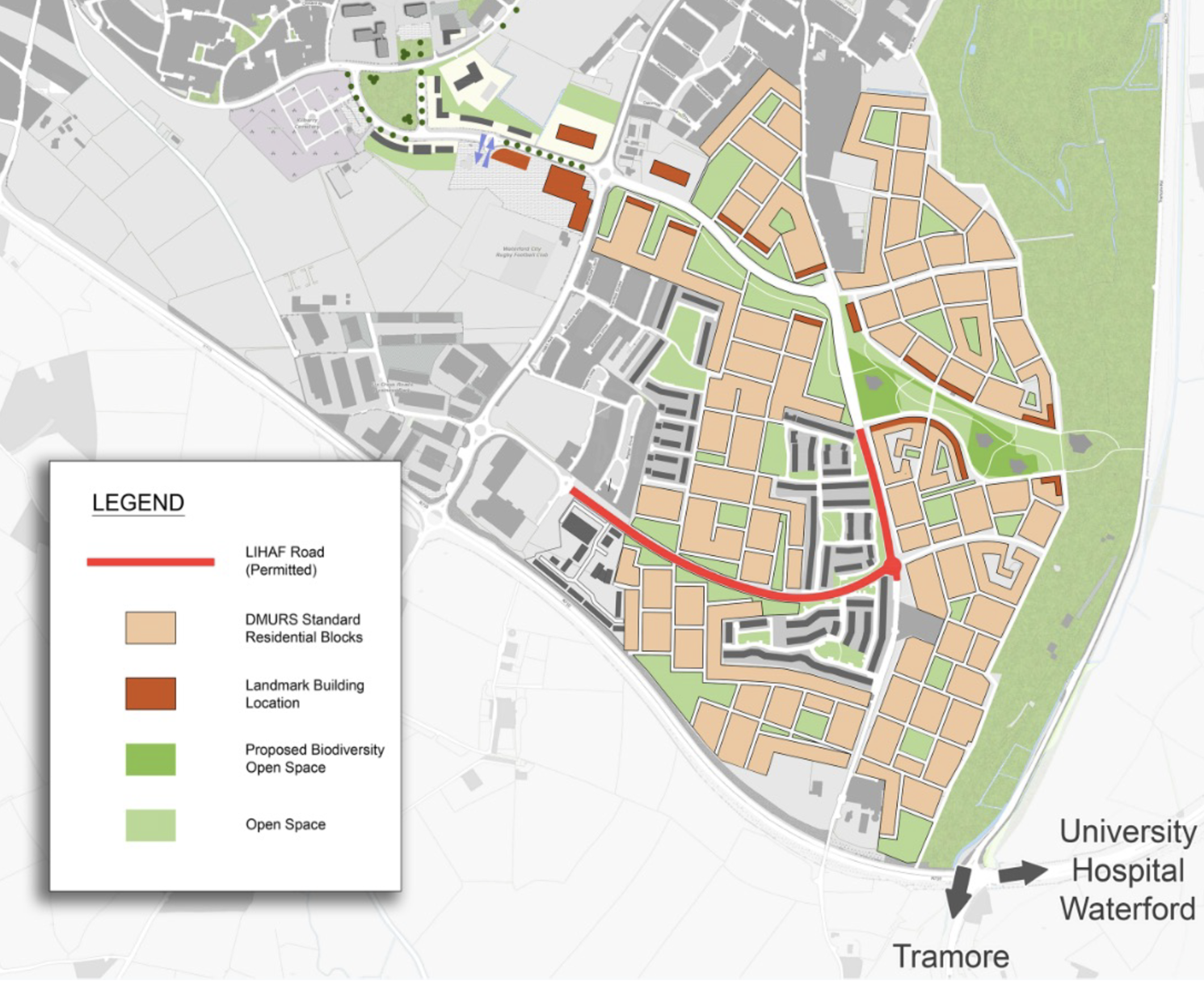
Figure 3.5 City South West Housing Masterplan
3.3.3 The Sacred Heart/ Ballytruckle/ Kilcohan/ Williamstown
The Ballytruckle/Kilcohan neighbourhood has experienced resurgence in residential development in more recent years despite the economic downturn which has primarily focused on the lands to the south of the neighbourhood, near the outer ring road. A large portion of the remaining undeveloped land in the neighbourhood is identified in the Development Plan as Phase 1 lands, being lands which are serviced or are readily serviceable due to the extension of the main drainage system to service lands between the Old Tramore Road and the Airport Road.
|
City South West Neighbourhood Policy Objectives |
|
|---|---|
|
W City 05 |
We will develop further the principle concepts set out in the design framework (Appendix 6) for the City South West Neighbourhood as part of a local area planning process during the lifetime of the Development Plan. In the interim, development proposals should have due regard to the strategies and objectives of the design framework. |
|
W City 06 |
We will require that all new development in the Kilbarry area adheres to the residential block layout set out in the design framework and Appendix 6 of the Development Plan while having regard to the policy objectives, residential densities and development management standards of the Development Plan. |
|
W City 07 |
We will collaborate with SETU, landowners and key stakeholders to support the further development of the University Campus and its integration into the built context of the city. |
|
W City 08 |
We will enhance Traveller accommodation and facilities in the area in collaboration with key stakeholders. |
The neighbourhood adjoins Ballinakill/Kilbarry pNHA, Waterford Nature Park and Kilbarry Park located further west adjacent to the City South West Neighbourhood. Both parks and the pNHA provide a unique biodiversity asset and public area for recreational use. Development proposals for lands adjoining the green wedge which surrounds the pNHA shall address the pNHA and buffer zone and shall include proposals for the protection of the pNHA. The pNHA provides a key element to support the development of a regional scale park and network of parks which is considered further in Section 3.8 of the Development Plan. Also, of note is the requirement to facilitate the development of a sustainable transport and biodiversity corridor along the outer ring road and development of zoned lands bordering the ring road will be required to provide this public facility as development progresses. Lands have been duly zoned for this amenity purpose.
Kilcohan neighbourhood centre accommodates a basic range of neighbourhood retail/service facilities. However, the site is limited and does not allow for expansion of a significant level to serve the wider neighbourhood area. Therefore, lands zoned for opportunity on the Airport Road are identified to facilitate the development of a neighbourhood centre. The design of development in this area should have particular regard to the elevated and sloping nature of part of the site and its exposed nature in relation to the Outer Ring Road. It is recommended that any development proposal for these lands be supported by a design framework demonstrating how it is intended to address these issues. An active travel route should be facilitated across these lands to link through Council owned land to the site the former St. Otteran's Hospital in order to enhance permeability and assist in achieving the 10-minute neighbourhood concept.
The general business lands are bounded by lands currently being developed for housing at Williamstown while the municipal golf club grounds are located opposite. For reasons of commercial viability this facility which occupies 51 hectares is now closed. These lands could form an important element in delivering a regional scale park (network) pursuant to policy objective W City 20 and the use in this regard will be considered further during the lifetime of the Development Plan.
The site of the former St. Otteran’s Hospital lies to the east of the Neighbourhood and provides a significant opportunity for regeneration and redevelopment (see Table 3.2) while accessing both the Williamstown Road and John’s Park. Similar opportunities are provided at St. Joseph’s which bounds the northern edge of the neighbourhood. Both these sites contain assets in terms of significant built heritage and tree stands which should be incorporated in any development proposals.
3.3.4 Dunmore Road/ Farronshoneen/ Ballinakill
The Farronshoneen/Ballinakill neighbourhood has largely been developed with few remaining greenfield sites. Future development in the neighbourhood will essentially consist of infill development closer to the city centre and the change of use of existing buildings with some regeneration possibilities. The neighbourhood adjoins the River Suir with access to the riverside and woodlands available, a 20m buffer of open space will be provided between development and the SAC boundary. It is an objective of this Plan to promote and provide for public access to the riverbanks and to reserve lands free from development to facilitate such access and to provide for a sustainable riverside walk along the southern bank of the River Suir from Canada Street to Blenheim.
The neighbourhood is served by the district centre of Ardkeen/Farronshoneen which is built out to a sustainable level in terms of retail function and the Ballinakill neighbourhood centre. Ardkeen centre is anchored by a food store, local shops, services and facilities with lands fully developed out. The Farronshoneen centre is anchored by a large food store and other retailers including a clothing store and DIY store which are serviced by a significant surface car park. The car park spaces available are in excess of the quantum required to service the retail development and given the lack of employment/office development in this neighbourhood along with the quantum of housing provided there is potential to develop additional employment uses to support the policy objectives of mixed use development, compact growth and placemaking. Furthermore opportunities exist to provide additional office/workspaces through the regeneration of the former Power Seeds site on the Dunmore Road and on undeveloped lands to the rear of the Ballinakill Centre which is situated along the Dunmore Road to the east of the neighbourhood and accommodates a convenience food store and a range of services. 
3.3.5 Dunmore Road/ Knockboy/ Blenheim
A Local Area Plan for the Knockboy area was made in 2003 with many of the objectives relating to access and road enhancements now completed i.e. Williamstown Road and Ballygunner Cross. The Plan set out a design framework for the village and contained a number of objectives to provide for a sustainable neighbourhood/village structure. This is consistent with the objectives of this Development Plan in terms of 10-minute neighbourhoods and placemaking in particular. It is an objective to ensure that the design and layout of new development provides for ease of movement and facilitates pedestrian and cycle access, and the use of public transport.
The neighbourhood is linear in form and thus it is an objective to strengthen the neighbourhood by developing nodal points such as a neighbourhood centre, a village green and a focal point for community facilities. Lands zoned for general business adjacent to St. Mary’s Scout Hall will continue to be zoned for such uses providing for local retail / commercial services / public services and facilities as appropriate.
Some residential infill opportunities remain across the area while more substantial residential development will be confined to the eastern area of the neighbourhood along the Dunmore Road, in and around Kings Channel and on lands between St. Mary’s Church and Cemetery and the Dunmore Road.
An opportunity presents in the Kings Channel area to facilitate re-wetting of a portion of the former floodplain of the Suir while providing a significant element of public amenity space around Kings Channel to form part of the network of amenity and biodiversity spaces as part of the regional scale park referred to in policy objective W City 20 while also linking into the riverside walkway and active travel route accessing the city centre.
3.3.6 Larchville/ Lisduggan/ Lismore Park
Residential land within the neighbourhood is substantially developed and as such it is envisaged that any further residential development within the neighbourhood will be in the form of infill development and in particular where opportunities arise to enhance the passive surveillance of open spaces or placemaking and enhancement of urban form. Other regeneration opportunities exist in and around the former Waterford Crystal site which would be suited to mixed development in support of enterprise and education and ancillary development in support of SETU, the institution forming an important element of the neighbourhood and the wider city. Further policy in this regard is set out in policy objectives EDU 02 and EDU 03 Chapter 4.
The wider Larchville/Lisduggan/Lismore neighbourhood contains commercial facilities such as the Lisduggan District (retail) Centre and the IDA industrial estate. We will encourage the further development of these facilities for the benefit of the neighbourhood and the city.
3.3.7 Ferrybank
The Ferrybank neighbourhood is divided between two local authorities, with the electoral division of Ferrybank located in Waterford City and the Kilculliheen electoral division located in County Kilkenny. The area lying with County Kilkenny is the subject of the Ferrybank and Belview Local Area Plan 2018. Ferrybank is perceived at local level to comprise of old and new Ferrybank, with the area characterised as old Ferrybank being situated in Waterford City and the newer area for the most part being situated in Kilkenny. Thus, there is a need for co-operation and joined up thinking between the two local authorities in the delivery of services, through the process of development management and planning for the future of the area. In this regard the setting up and operation of the MASP implementation body will be critical to providing balanced development across the administrative boundary with Kilkenny County Council as envisaged and supported in Policy Objectives W City 22 and 31.
As the bulk of greenfield development land in the area is located in County Kilkenny, most of the new residential development has taken place outside of our administrative area. The Ferrybank area within Waterford City is essentially built out with any future development opportunities being infill development or relating to the change of use of existing structures. In this regard the greatest opportunity for new development, including office, residential, retail, tourism and amenity, sits on the site of the North Quays Planning Scheme along with adjacent lands in and around the existing bus depot. Plans for development as part of and in support of the North Quays Planning Scheme include the relocation of the existing train station, development of an integrated transport hub, the provision of a new sustainable transport bridge linking the South Quays, public spaces, improved roads and access in the vicinity of Abbey Road and the important link between the Waterford Greenway and the Greenway to New Ross.
Ferrybank neighbourhood is served by an area of lands identified on the zoning map as general business which currently accommodates a number of local retail and commercial services. A site within the Ferrybank neighbourhood, adjoining the New Ross Road, is designated as a District Centre. A mixed-use development has been permitted on this site providing for comparison and convenience retail, retail warehousing, a medical centre, gym, office use, food court and motor sales.
Belview Port is located on the periphery of the area and is serviced via the national road network and rail network. The Port of Waterford has significant plans relating to the strategic development of the port functions and we support these in the interest of building the economic function of Waterford as a regional city of scale. Reference should be made to policy objectives W City 20 and 31 for further details.
Insert image here
3.3.8 MASP Rural Area
A substantial proportion of the City Area, approximately 40%, retains its rural character. This rural or urban fringe area wraps around the built-up area and provides an outer boundary to the development of the City. The area is subject to development pressures arising from the expansion of the City. The development strategy of enhancing the compactness of the city and of providing a clear demarcation between the built up and rural areas are designed to:
- Protect the special character and landscape setting of the City,
- Provide for the orderly development and growth of the built footprint of the City and prevent urban sprawl and ribbon development.
- Safeguard the countryside from encroachment by urban generated development,
- Assist in compact growth and urban regeneration by encouraging the renewal of obsolete areas within the existing built-up area.
The rural area of the City is predominantly in agricultural use. This area is subject to development pressures including demand for urban generated housing and industrial/commercial development. These pressures, combined with location on the urban fringe, can make the continuation of sustainable agriculture difficult. This area of the city will be subject to the relevant policy objectives set out in the Development Plan relating to the relevant land use zoning pertaining to the area. In addition, the rural area provides opportunities for both passive and active recreation for the citizens and this usage, where compatible with sustainable agricultural practices, will be encouraged.
3.3.9 City Centre
While the neighbourhoods set out above will facilitate population increase and sustainable growth over the lifetime of the Development Plan, we consider that the city centre and inner urban areas will play a significant role in the development of the Waterford MASP area as they give expression to Waterford’s identity as a modern, dynamic, innovative European city and to its future status as a Learning City, a Smart City, and a University City.
The spatial expression of the City Centre consists of a number of distinct quarters or nodes, each presenting opportunities for change while an integrated approach to develop the node locations and link them together will contribute significantly to the change dynamic. Over time other nodes will be identified as the City Centre becomes more diverse and vibrant with more people living in or close to the City. The principle nodes can be summarised as:
- The Retail Node around City Square, George Street and developing into the Apple Market Area.
- The Tourism and Heritage Node around the Viking Triangle and The Mall.
- The Evening and Night-time Node around John Street and Apple Market.
- The Cultural Node around O’Connell Street and Garter Lane – The Waterford Cultural Quarter.
- The North Quays Node comprising the mixed-use development of the SDZ area – the North Quays Innovation District; and,
- The Court House and Environs – Lifting the Quality of the urban environment for a wider urban area extending out from the City Centre.
Actions to influence the change dynamic and deliver the potential of these nodes includes, active land management and regeneration of underutilised lands and buildings above ground floor, actions to support the mixed use function of the city centre (including inter alia retail, residential & community, cultural, entertainment, employment & education), enhanced public realm (particularly the South Quays), enhanced amenity spaces and enhanced mobility along with delivery of key infrastructure. The policy objectives of this Development Plan will support these actions in terms of public and private capital investment and the appropriate management of development.
The city centre has experienced significant public capital investment in recent years i.e. the Viking Triangle, Applemarket and public realm, building regeneration, flood relief works on South Quays and along John’s River; however notwithstanding these recent achievements the redevelopment of the South Quays has not progressed and has heretofore remained unzoned despite its capacity to deliver transformational change in the heart of the historic city centre in terms of significant amenity spaces to assist in the delivery of the Cultural Quarter, acting as a terminus for the Waterford and New Ross Greenways and other sustainable transport and biodiversity corridors in addition to dispersed opportunities for commercial uses to complement the mixed use function of the city centre and utilising opportunities presented by heritage and other assets located along the South Quays . The Development Plan has zoned this area for Regeneration purposes while the more detailed spatial configuration for the entire area will require further consideration by way of an urban design framework to address the following:
- Site appraisal including the historic context i.e. ACA’s RPS.
- Mobility links, both internal and external including that from the Waterford Greenway, riverside walkways / cycleways and connections across the South Quays carriageway.
- Significant public realm and public amenity areas as part of the broader wide-open space and amenity strategy proposed in policy objective W City 20.
- The sustainable transport bridge link to the North Quays and Ferrybank neighbourhood.
- Pockets of new commercial development.
- Traffic demand management and displacement of car parking; and,
- River leisure uses which promote and support diverse uses along the riverside and within the river including public baths and a maritime museum where feasible.
- A review of traffic management along the R680.
Given the outstanding location, the existing and potential quality of the physical environment and the existing infrastructure in the area it is therefore an objective of the Development Plan to complete an urban design framework for the South Quays area during the lifetime of the Plan. In the interim it will be possible to progress the implementation of the final section of the Waterford Greenway, the new sustainable transport bridge and other planned public amenities and public realm improvements prior to finalising any design framework which can then incorporate these important elements.
3.4 Vitality and Viability
Vitality and Viability concepts are central to sustaining and enhancing the city centre and supporting the implementation of the town centre first concept, compact growth and placemaking. Vitality is a measure of how active and buoyant an urban centre is while viability is concerned with the commercial well-being of the centre. They both are dependent upon many factors, including its community, the range and quality of activities in a centre and its mix of uses, its accessibility and ease of mobility, and its amenity, appearance, maintenance and safety.
The overall strategy of maintaining and enhancing the role of the City Centre will be pursued by maintaining and developing policies to help existing uses, through regenerating the historic centre; through encouraging conservation and urban renewal activities; through managing and controlling traffic; and by co-ordination and collaboration between public and private actors and investment.
Many of the policies set out elsewhere in the Development Plan relating to these strategies can be applied across all urban centres throughout Waterford County and the neighbourhoods outside the city centre i.e. the retail strategy, mobility, placemaking etc. The policies set out in this section hereunder should be considered in the context of the city centre in the first instance but can be applied elsewhere as appropriate.
|
Vibrancy & Vitality: Land Use Mix Policy Objectives |
|
|---|---|
|
W City 09 |
In the interest of vitality and viability of the city centre and the delivery of a vibrant diverse community and mix of uses across the city centre we will:
|
3.4.1 Entertainment and Evening/ Night-Time Uses
The development of the evening and night-time economy is an important part of any city/town and it is essential to ensure that vitality and viability of the City/Town Centre is retained after hours. In this regard we will seek the integration of retail, leisure, restaurants and bars in development proposals and apply a series of policy objectives to ensure that the City/Town centre retains a high level of amenity for both residents and visitors and a welcoming and safe character during evening and night time periods.
Waterford City and County Council will also require proposals for casinos and gaming arcades to be subject to the relevant legislative provision of the Gaming and Lotteries Act 1956 as amended and regulate the development of such land uses accordingly.
|
Vibrancy & Vitality: Entertainment, Evening/ Night-Time Uses Policy Objectives |
|
|---|---|
|
W City 10 |
We will have regard to the following when considering development proposals for evening and night-time uses:
|
|
W City 11
|
We will support proposals for development involving evening and late-night commercial, retail, cultural, food and beverage or entertainment uses within, or immediately adjacent to, the defined city/town centres or local service centre, where it can be demonstrated that the development will enhance the character and function of the area and will not have a detrimental impact on the existing amenities of the area (including residential); this may include but is not limited to; extended opening hours, proposals for outdoor dining and event spaces, and proposals for the greater utilisation and public access to existing heritage assets. |
3.4.2 Public Realm
The revitalisation of the City Centre is very much dependent upon the creation of new retail, cultural, amenity and other attractions with associated environmental improvements to the public realm. The identified opportunity sites within the City Centre present opportunities for additional new retail led mixed use developments which in turn will sustain the vibrancy and vitality of the City Centre. Accordingly, through our active land management role, we will pursue and promote the redevelopment of these sites during the period of the Development Plan period. As some of the identified opportunity sites are more peripheral to the centre investment in environment improvement along the principal intervening area and other enabling infrastructure will be required to ensure that commercial synergy between these areas and the centre is enhanced.
|
Vibrancy & Vitality: Public Realm Policy Objectives |
|
|---|---|
|
W City 12 |
To improve the experience of visitors and residents in the City Centre and continue the enhancement of a high-quality city centre which invites, encourages and supports sustainable movement we will:
|
3.4.3 City Centre Residential Neighbourhood
Providing opportunity and scope for new residents to move into the City Centre will require the continued improvement to the amenity and character of the area and we are committed to continued investment in this regard. It is recognised however that there can be significant challenges to redeveloping older properties to a modern standard of living with particular reference to achieving stringent building standard and economic barriers. There is scope however to identify innovative solutions to overcome some of these challenges. We will collaborate with key stakeholders such as SETU, the LDA and property owners in this regard over the lifetime of the Development Plan and seek capital investment through the URDF and other funding streams to improve the resilience of our building stock. We will also promote inner city living in our role as a housing authority where feasible as we did successfully at Chairman’s Arch and in any mixed-use development proposals in a manner consistent with the Housing Strategy.
|
Vibrancy & Vitality: Residential Neighbourhood Policy Objectives |
|
|---|---|
|
W City 13 |
In order to provide opportunities for the growth of a sustainable City Centre neighbourhood we will apply the following when assessing proposals for development:
|
3.5 Strategic Employment Locations
Waterford’s location on the south coast accessible via our ports and airports to Dublin, continental Europe and Britain underlines the importance of Waterford as a Regional City of scale. The potential for further sustainable and resilient growth will be underpinned by expansion of a range of services and facilities to support growth in the enterprise dynamic and build critical mass into the economy. The City and its Metropolitan Area are already home to a diverse economic base including:
- Life Sciences: BioPharma, Pharmaceuticals, Medical Device, Biotechnology, and Nutraceuticals.
- ICT: Ecommerce, VR, Cloud, IoT, Retail Tech, Device Management, AI, Data Intelligence, and Mobile Development.
- Engineering: Advanced Manufacturing, Engineering, Equipment Manufacturing, and Construction.
- Financial Services: Global business, Financial Services, Fintech, Regtech, Insurtech, and Global Payments.
- Agri: Agri Food and Drink, Agri-Tech, Bioeconomy, and Ingredients manufacturing.
- Creative: Design, Craft Industry, and TV & Film Production; and,
- Tourism: Viking Triangle, Waterford Greenway, Waterford Cultural Quarter, Heritage and Natural Capital, Mt. Congreve.
In addition to our commitment to enhance the opportunities for employment across the City and County as set out in Chapter 4 Economy, Education and Retail, the function of Waterford as a Regional City of Scale will be dependent on the creation of the critical mass of an additional 9,130 jobs to 2026 and a further 4,565 jobs to 2031, based on a jobs to workers ration of 1.6:1 as envisaged in the NPF and RSES. To assist in this regard and to build capacity for expansion across our diverse economic base the following strategic employment locations have been identified:
- Waterford City Centre including Viking Triangle.
- North Quays Innovation District.
- Port of Waterford – Belview.
- The Belview Port Industrial area & IDA Lands - located approximately 5km downstream of Waterford City in the River Suir estuary. The Port at Belview is a strategic national, regional and county asset with good road and rail links. The role and status of the port nationally and regionally and its industrial land capacity should be strengthened to support and promote a balanced multi-modal freight transport policy that safeguards the importance of rail transport as a means of access to the Port.
- Waterford Airport and Business Park plays a critical role in the development of Waterford and the South East, in terms of accessibility, supporting economic development and tourism. Reflecting this, lands have been zoned at this location to facilitate the development and expansion of the Airport as ‘Airport Area’.
- The Research and Innovation Centre at SETU’s Carriganore Campus.
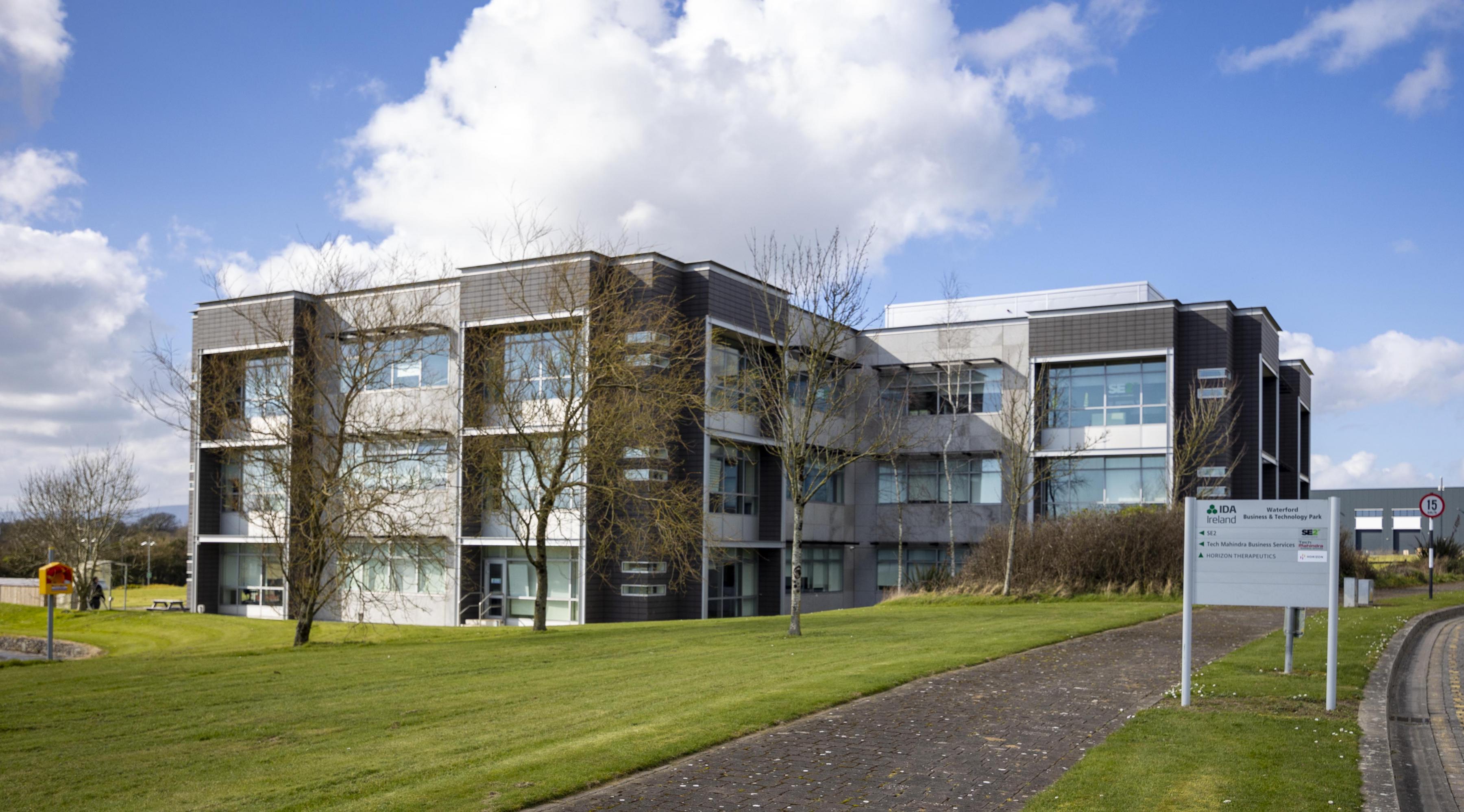
- IDA Business and Technology Park on the outskirts of Waterford city. It will be appropriate in the context of the MASP to explore potential synergies between the SETU ArcLabs Carriganore campus and the IDA Business and Technology Park adjacent to it with the view to creating an extended Knowledge Campus in support of innovation-centred industry;
- An expanded strategic land bank at Knockhouse adjacent to the N25 and accessed from the R710 outer ring road/Cumann na mBan road at SETU Arena.
- Former Waterford Crystal Site on the Cork Road; and,
- Waterford Cultural Quarter centred on O’Connell Street.
In addition to promoting and facilitating the commercial development of these strategic employment locations by way of infrastructure provision, placemaking and supporting community and amenity infrastructure to attract and support our communities and neighbourhoods, we are also aware of the need to support the continued development and expansion of the SETU, University Hospital Waterford, the Port of Waterford and Waterford Airport as key pieces of infrastructure for the region in their own right in addition to key drivers for employment and our economy.
It is important also to recognise, foster and support new growth and the underlying ecology and culture of our economy through business supports and our collaborative effort. Initiatives such as the Smart City and the UNESCO Learning City provide additional opportunities to innovate collectively as a City in how we connect to do business, how we learn and how we grow to be a more diverse and resilient economy.
|
Strategic Employment Locations Policy Objectives |
|
|---|---|
|
W City 14 |
In a manner consistent with Section 8 of the Waterford MASP (RSES), we will support and facilitate the continued economic expansion of our economy at the key strategic employment locations identified in the Development Plan subject to compliance with the principles of proper planning and sustainable development and the policy objectives and development management standards of the Development Plan. |
|
W City 15 |
Through our Local Enterprise Office we will collaborate with other agencies such as Enterprise Ireland, South East Business Innovation Centre, SETU, Waterford Chamber, the South East Regional Skills Forum, individual enterprises and other key stakeholders to develop our knowledge base and build our critical mass of innovative and resilient enterprises. |
|
W City 16 |
We will continue to seek funding through URDF and other sources to enhance the physical quality of our city centre, deliver transformational regeneration projects and innovative solutions to sustainable urban placemaking, and thereby enhance the attractiveness of Waterford City as a place in which to visit, invest and live. |
|
W City 17 |
We will promote and support a diverse range of symbiotic land uses across the City and the City Centre in particular. We will facilitate the expansion of existing and establishment of new economic uses and clusters where appropriate in the interest of growing the City Centre as a dynamic and commercially resilient urban space and neighbourhood. |
|
W City 18 |
We will build on existing higher education infrastructure and establishment of SETU, seek to enhance third-level provision in the City, and expand and integrate education provision more broadly in support of the designation of the city as the Regional Capital, a University City and Learning City. |
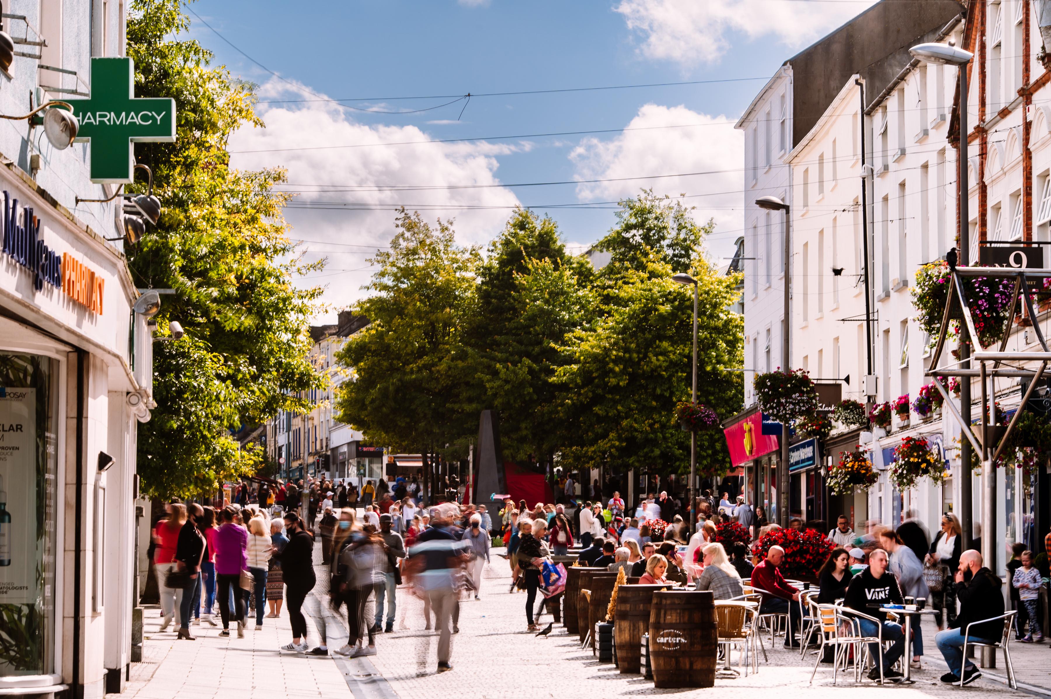
3.6 Waterford City Retail Strategy
The City Centre needs to assert itself as the retail, commercial and cultural capital of the South East Region. The City’s retail representation has remained static for a number of years now, so much so that other centres in the region are currently challenging for retail primacy within the South East. The redevelopment of key sites within the City Centre, such as the North Quays and Michael’s Street, is of paramount importance in order for the City to strengthen its role and function and compete as a high-level retail destination. In this regard, the City Centre must be targeted and be the focus for higher order comparison retailing as well as developing as a living city.
Retail Planning Guidelines for Planning Authorities – 2012
The Retail Planning Guidelines identify five key policy objectives to be progressed by Planning Authorities in planning for and addressing the development requirements of the retail sector, these are outlined below:
- Ensure retail development is plan-led.
- Promote city centre vitality through the sequential approach to development.
- Enable good quality development in appropriate locations so ensuring competitiveness.
- Facilitate a modal shift in retail access to non-private vehicle modes and,
- Delivering quality urban design outcomes.
Retail Design Manual – 2012
This is a companion document to the Guidelines detailed above and is intended to guide planning authorities in formulating appropriate design polices and development management responses when dealing with retail issues. They also provide relevant parties with evidence-based quality principles to ensure that new retail development meets the highest standards for design, streetscape integration and connectivity.
3.6.1 Waterford City and County Retail Strategy 2020
The Retail Strategy for Waterford City and County (Appendix 4 and Chapter 3 Part 2 of the Plan) aims to consolidate Waterford city centre retail core as the premier retail destination in the County and Region, to promote retail development in Dungarvan and Tramore town centres, suburban district/ neighbourhood centres and to cater for local retail needs of communities across the County.
3.6.2 The Retail Hierarchy
The retail hierarchy for the City and County is set out in Table 3.3. Waterford City is at the top of the hierarchy and forms Tier 1 within the retail hierarchy. The second-tier centres consist of the key town of Dungarvan, Tramore and existing district/suburban centres in the environs of Waterford City. Tier 3 consists of Urban Towns, while Tier 4 contains the Local and Neighbourhood Centres in Waterford City with Tier 5 comprising of Small Local Shops serving residential areas/ estates and shops attached to petrol filling stations etc which serve a local catchment area.
|
Table 3. 3 Waterford Retail Hierarchy |
||
|---|---|---|
|
Level/Function |
|
Centre |
|
Tier 1 |
Metropolitan |
Waterford City Centre |
|
Tier 2 (L1) |
Sub-Regional |
Dungarvan Town Centre |
|
Tier 2 (L2) |
District/Suburban Centres |
Tramore Town Centre |
|
|
(In excess of 10,000 Population) |
Ardkeen/Farronshoneen |
|
|
|
Ferrybank Centre Abbeylands |
|
|
|
Kilbarry, Tramore Road, Inner Relief Road |
|
|
|
Waterford Shopping Centre, Lisduggan |
|
Tier 3 |
Small Towns and Rural Areas |
Dunmore East |
|
|
(1,500 – 5,000 Population) |
Portlaw |
|
|
|
Lismore |
|
|
|
Tallow |
|
|
|
Kilmacthomas |
|
|
|
Cappoquin |
|
Tier 4 |
Local Shopping |
Ballinakill |
|
|
|
Ballybeg |
|
|
|
Carrickphierish |
|
|
|
Cleaboy |
|
|
|
Hypermarket, Morgan Street |
|
|
|
Kilcohan |
|
|
|
The Outer Ring Road Williamstown, Ballygunner Road (opposite Meadowlands). |
|
|
|
Knockboy |
|
Tier 5 |
Other |
Local Shops in Waterford City |
|
|
|
Villages in Waterford County |
3.6.3 Assessment of Retail Developments
In accordance with the Retail Planning Guidelines, a number of relevant development management criteria have been identified for the assessment of retail developments. It is important to note that these criteria should be read in conjunction with other requirements of the Plan, in particular those set out in Volume 2 Development Management Standards, as well as the Retail Strategy in Appendix 4.
3.6.4 Multifunctional and Flexible City Centre
The centre of Waterford City needs to become more resilient and adaptable to change. The City Centre must evolve to become a multifunctional and flexible space which, in addition to providing important retail uses, also provides a range of other uses including residential, leisure, recreation, employment, tourism, civic, community, cultural, health and education for the communities they serve. The combination of these uses will assist in further adding to the vibrancy and vitality of existing uses and can help to foster a real sense of place, identity and inclusivity for local residents and visitors alike.
While this section focuses primarily on Waterford City, the principles can be applied to Dungarvan and Tramore as well as small towns and villages as multifunctional centres in the wider context of retail planning policy, it also draws on the approach to the creation of a sense of place (please also refer to policy objectives of Chapters 7 and 8).
In general the retail sector as a whole has undergone significant change in recent years due to a shift in shopping patterns and the rise of internet shopping, ‘click and collect’ and the emergence of ‘omni channel consumers’, who use a combination of traditional brick and mortar retailing combined with online platforms to make their purchases.
The focus going forward in physical retailing is on what is referred to as ‘experiential’ retail, with a resultant shift from a town centre dominated by comparison retail offer to one where more time is spent on ‘experiences’ such as leisure, culture, heritage, food, beverages and retail services. Traditional economic indicators alone are no longer sufficient to measure the performance of a town in what is now a much more diverse and complex offer.
This new departure presents considerable opportunity for Waterford. The City already provides an array of leisure, employment, housing, cultural/heritage and education opportunities in addition, to a broad retail offer. The trends identified above can only help to strengthen the city. Other larger urban, suburban district, neighbourhood and small towns/ villages centres also stand to benefit from the trends identified above, in particular the increased popularity of neighbourhood and local shopping.
3.6.5 Core Shopping Area
The core shopping area of Waterford City is identified on Figure 3.5. The area extends from the North Quays southwards and includes Barronstrand Street, Broad Street, John Roberts Square, Georges Street, Gladstone Street, Little Patrick Street, Patrick Street, Arundel Square, Conduit Lane, Exchange Street, Kiezer Street, Henrietta Street, New Street, Stephen Street and Michael Street and the blocks between these streets.
In order to facilitate a multifunctional/ flexible approach to the city centre as well as maintaining and strengthening the retail character of the core shopping area, which can be adversely affected by dead frontage and lower-order retail uses, the retail core has been designated into Zone 1 and Zone 2 streets. The function of these zones area explained below, with lands use criteria set out in Table 3.4 and their location displayed in Figure 3.6 and 3.7.
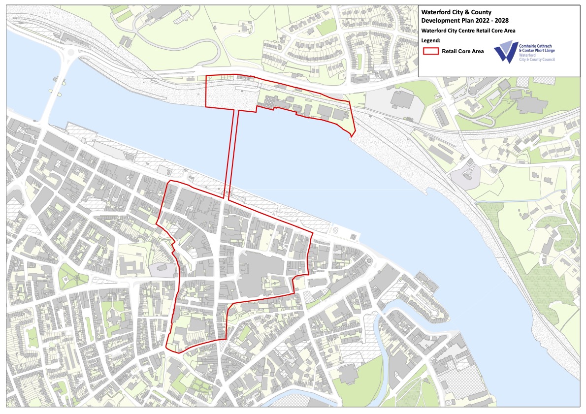 Figure 3.6 Waterford City Retail Core Area
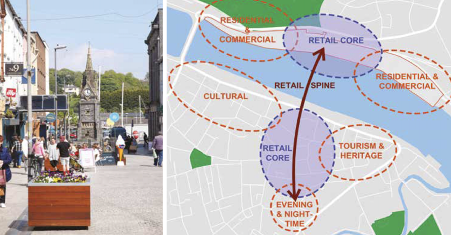
Figure 3.7 City Centre Precincts (Source North Quays Planning Scheme)
|
Table 3.4 Core Retail Area Street Types |
|
|---|---|
|
Type |
Description |
|
Zone 1 |
Includes the main shopping streets of Michael Street, Broad Street, Barronstrand Street, Great George’s Street, Blackfriars Street, Arundel Lane, Arundel Square and Peter’s Street within Waterford City Core Retail Area. In order to strengthen the retail offer of these streets, the land-use objectives will be in favour of higher/medium order retail use at ground floor level. Proposals for service outlets such as, call centres, bookmakers, take-aways, amusement arcades and casinos will be discouraged at ground floor level. Other non-retail uses such as pubs, cafés, restaurants, will be considered on their merits; such developments will be permitted provided the primary retail function of the street will not be undermined. |
|
Zone 2 |
Includes all other streets and lanes within the Core Shopping area. These streets already have a mix of retail and nonretail uses. In order to strengthen the retail character of these streets, further development of retail frontages will be encouraged. Complementary non-retail uses such as a café and restaurants that add to the vibrancy of the street and create a mixed-use environment to provide for a more integrated shopping and leisure experience, will be considered favourably but with regard also to the primary retail function of the street. Applications for other retail service outlets and other uses such as internet cafés, call centres, bookmakers, take-aways, off-licences, amusement arcades, 'vape-shops', ‘cash for gold’ and ‘Pound’ type shops, car rental, financial institutions and offices at ground floor level will be assessed on their merits, and may only be permitted where such development would not result in a predominance of such similar non-retail frontages on the street. |
|
Other Areas |
Within other areas of the City Centre the Planning Authority will seek to promote the revitalisation of vacant / derelict properties / shop units as a priority. Any proposals for new retail/commercial developments or the conversion of existing residential buildings for retail/commercial uses will be assessed on their merits and in accordance with the sequential approach to retail/commercial development. Applications for other retail service outlets and other uses such as internet cafés, call centres, bookmakers, take-aways, off-licences, amusement arcades, 'vape-shops', ‘cash for gold’ and ‘Pound’ type shops, and other uses that can adversely affect the character of an area will be assessed on their merits, and may only be permitted where such development would not result in a proliferation of such similar frontages/uses on the street. |
The purpose of Zone 1[3] is to protect the primary retail function of the core shopping area with an emphasis on higher/medium order comparison retail and a rich mix of uses, while Zone 2 streets designation allows for a more flexible and multifunctional approach to be taken to uses on these streets
3.6.6 City Centre First/ Sequential Approach
Where the location of a proposed retail development is in an edge‐of‐centre or out‐of‐centre location, a sequential test must be applied in line with the Retail Planning Guidelines.
The order of priority for the sequential approach is to locate retail development in Waterford City Centre core shopping area and the suburban district centres, and only to allow retail development in edge-of-centre or out-of-centre locations where all other options have been exhausted.
Applicants will be required to consider altering their formats and considering smaller sites and multi‐storey options. In accordance with RPO 151(f) and (g) of the Regional Spatial and Economic Strategy, adequacy of parking provision at non‐residential sites will not be considered as a measure for site suitability in sequential tests.
Where retail development in an edge-of-centre site is being proposed, the applicant must demonstrate that there are no sites or potential sites including vacant units within a city centre or within a designated district/suburban centre that are (a) suitable (b) available and (c) viable, can that edge-of-centre site be considered.
3.6.7 Suburban District Centres and Local Shopping
Retail provision has an important role to play in the creation of vibrant centres and sustainable neighbourhoods in both existing and new areas and will become more important in the creation of the City’s 10-minute neighbourhoods. The Council will encourage appropriate retail provision throughout the city in accordance with the Retail Planning Guidelines (2012) and the settlement and retail hierarchy, core strategy and retail strategy.
3.6.8 Retail Warehousing
The Waterford City and County Retail Strategy highlights that there will be limited demand for further retail warehousing floorspace in Waterford City or County in the short term.
The Retail Planning Guidelines, state that individual retail units should not be less than 700 sq. metres and not more than 6,000 sq. metres in size. These figures are gross floor area, including storage and garden centres. In respect of retail warehouse developments outside town centres, it is essential that the range of goods sold is restricted by planning condition to bulky household items such as DIY products, carpets, furniture, and electrical goods. Failure to do so may have a negative impact on the vitality and viability of the town centre area.
The Guidelines provide for a cap on large-scale single retail warehouse units in excess of 6,000 sq. metres gross (including any ancillary garden centre) due to their potential impact on the road network and their potential for creating local monopolies which would inhibit competition within local catchment areas. However, the 6,000 sq. metre gross cap can be relaxed in the exceptional circumstance. The scale of such outlets requires a regional, if not a national, population catchment. Accordingly, proposed exceptions to the 6,000 sq. metres retail warehouse cap may be considered on the merits of individual development applications in the five cities of Dublin, Cork, Waterford, Limerick/Shannon and Galway. In order to be acceptable from a planning perspective, any proposal for an individual large-scale retail warehouse with a floorspace in excess of 6,000 sq. metres gross must demonstrate compliance with the criteria set out in the Section 4.11.2 of the Retail Planning Guidelines.
3.6.9 Joint Retail Strategy for the Waterford MASP Area
The Retail Planning Guidelines (2012) states that ‘Joint or Multi-Authority Retail Strategies must be prepared’ for urban areas and identifies Waterford and Counties Kilkenny, Tipperary and Wexford as the planning authorities which should participate in the preparation of the Joint Retail Strategy.
Having regard to the provisions of the Retail Planning Guidelines, 2012, and in particular paragraph 3.5 ‘Joint or Multi-Authority Retail Strategies’, and the Southern Regional Assembly ‘Regional Spatial Economic Strategy’, 2040, Waterford MASP Policy Objective 19 (a), the Council is committed to delivering a Joint or Multi-Authority Retail Strategy for the Waterford MASP Area.
|
Waterford City Retail Policy Objectives |
|
|---|---|
|
W City Retail 01 |
Retail Guidelines Ensure that all proposed retail development accords with the relevant policies of the Development Plan and the requirements and criteria as established within the Retail Planning Guidelines 2012, the accompanying Retail Design Manual and the Waterford City and County Retail Strategy 2020 (or any subsequent updates of the above). |
|
W City Retail 02 |
Retail Hierarchy Retail development should be of a type, size and scale appropriate to the centre, having due regard for the retail hierarchy and the appropriate level of development at each tier. The appropriate level of development at each tier is defined in Section 4.12.6 of the Development Plan. |
|
W City Retail 03 |
Primacy of City Centre To affirm, maintain and protect the status of Waterford City Centre’s retail core area as the primary shopping area for high and medium order retail goods in the Southeast Region, affording a variety and mix of shopping, cultural and leisure attractions. |
|
W City Retail 04 |
City Centre First Approach/ Sequential Approach The retail core area will form the main focus and preferred location for new retail development. The Council will apply the sequential approach to retail development proposals outside the city centre retail core area. Edge of centre sites or out of town centre sites will only be considered when it has been clearly demonstrated that all suitable available and viable sites in the city retail core area/ suburban district centres have been fully investigated and considered in accordance with the Retail Planning Guidelines and in particular the sequential test. |
|
W City Retail 05 |
Suburban and Neighbourhood Centres To promote retail provision in the following location:
The type of retail should be of an adequate level, type, scale and the nature of the floorspace proposed should be appropriate to that centre in the context of the guidance set out in the Retail Planning Guidelines (2012) or any update thereof. Any proposal for significant comparison floorspace should be supported by a clear assessment as to whether such development would have a material impact on Waterford City Centre. The sale of high and middle-high order comparison goods will be restricted to the City Centre area to protect and strengthen its retail primacy. |
|
W City Retail 06 |
Multifunctional Centres We will support the development of Waterford City Centre, Suburban District Centres and Neighbourhood Centres as accessible, multifunctional centres which are of a high quality urban realm and placemaking standard, which provide a variety of uses at an appropriate scale, which facilitate the development of the City’s 10 minute neighbourhood concept and meet the needs of the communities they serve. In relation to the core retail area in Waterford City Centre we will promote active uses at street level on the principal shopping streets in the city centre retail core having regard to the criteria for Zone 1 and Zone 2 streets set out in Table 3.4. |
|
W City Retail 07 |
Retail Warehousing The Council will strictly control additional new retail warehousing in Waterford City for the duration of the Plan. Any application for retail warehousing will be required to demonstrate that the proposal will not impact adversely on the vitality and viability of the City Centre in accordance with the criteria set down in the Retail Planning Guidelines for Planning Authorities (2012) or any update thereof and the Retail Strategy. |
|
W City Retail 08 |
Joint Retail Strategy Within one year of adoption of the Waterford City and County Development Plan we will prepare a Joint Retail Strategy for the Waterford Metropolitan Area in conjunction with Kilkenny County Council/adjoining relevant local authorities and the Southern Regional Assembly, in accordance with the Retail Guidelines (2012) and Waterford MASP policy Objective 19, and we will vary the Development Plan as necessary following completion of the Joint Retail Strategy. |
3.7 Waterford Cultural Quarter
Waterford Cultural Quarter is located along the spine of O’Connell Street and its peripheral streets and spaces (as displayed across) linking Great George’s Street to Waterford Distillery and is the focus of culture-led regeneration in the city. The linear streetscape of fine buildings which was once the  business and enterprise hub of Waterford now offers an opportunity to repurpose the area to support liveability, knowledge, experimentation, creativity and innovation. To support the delivery of the Cultural Quarter and a vibrant, diverse and resilient city centre Waterford City and County Council produced the first strategic plan for the area in 2017 which recognised the important role culture plays in developing identity for city neighbourhoods and in delivering social and economic outcomes. We have now prepared a strategic plan for the period 2021-2025 which focuses on buildings and uses, the public realm and placemaking and collaboration. We are committed to supporting the vibrancy and diversity of the area and developing its potential for a new generation and an enriched city centre neighbourhood/community.
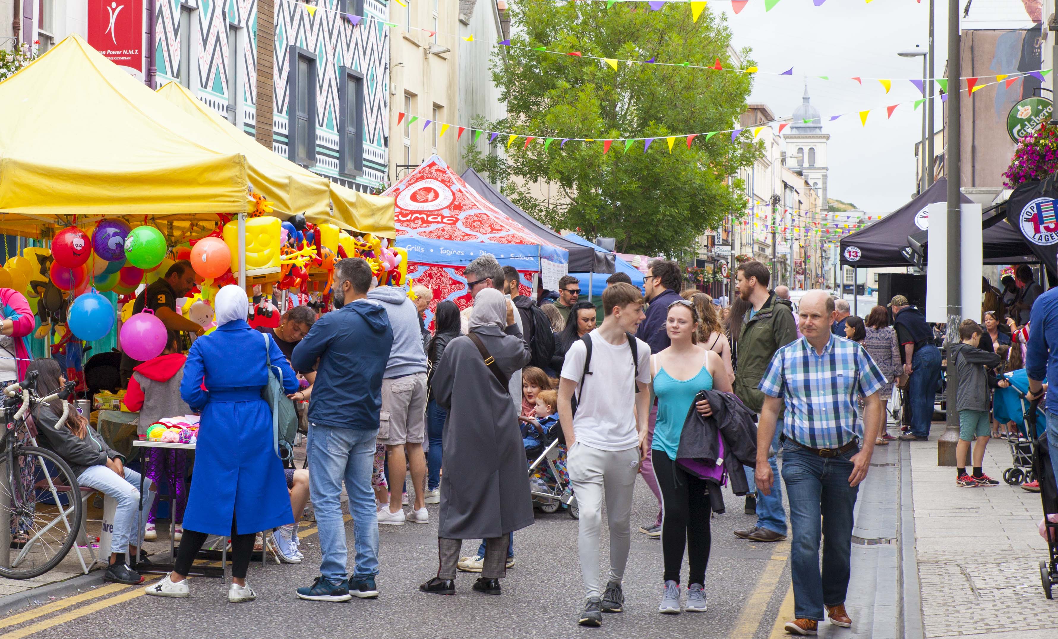
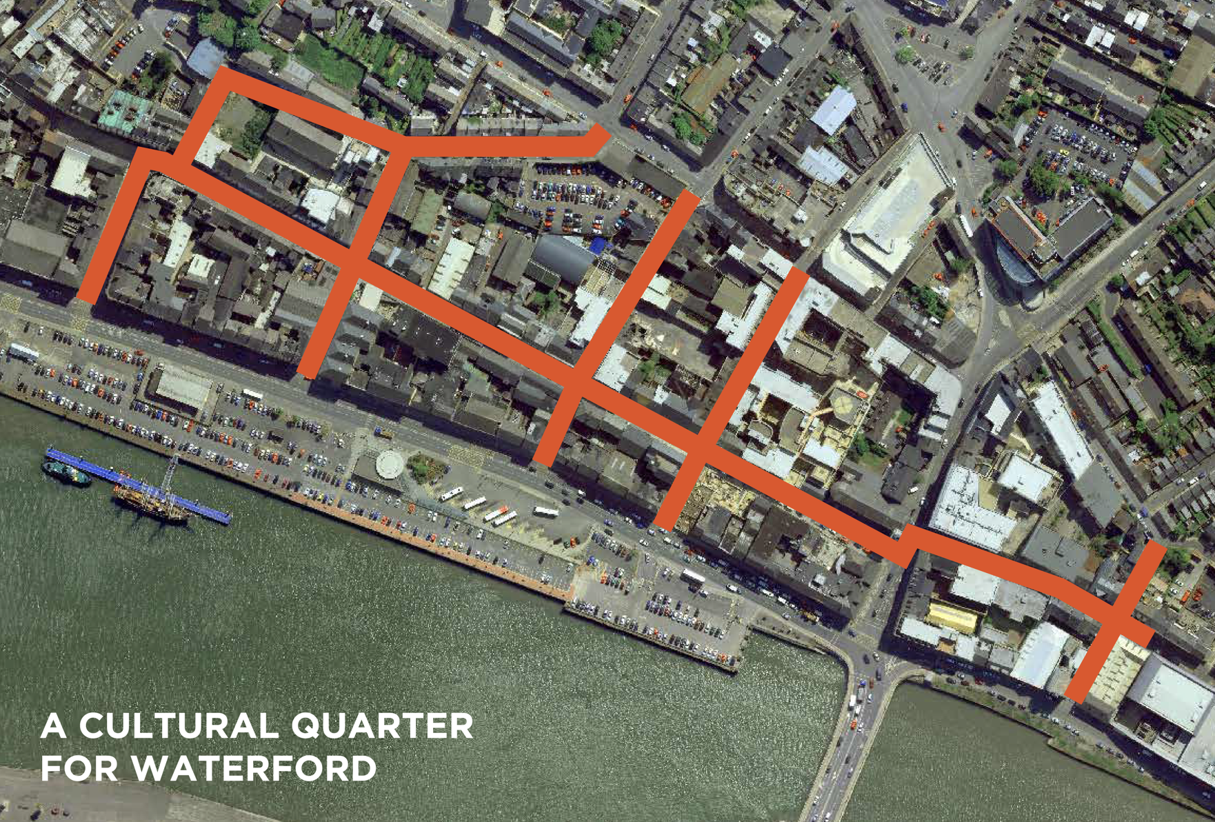
|
Waterford City Cultural Quarter Policy Objective |
|
|---|---|
|
W City 19 |
In support of RSES MASP Policy Objectives 6, 19 and 20 which seek to enhance the regeneration, vibrancy, tourism and strategic employment opportunities for Waterford City through delivery of the Waterford Cultural Quarter, we will implement the actions set out in the Waterford Cultural Quarter Strategic Plan 2021-2025 and seek further opportunities and sources of funding to support the collaborative efforts of key stakeholders and community groups in building the creative and innovative potential of the Cultural Quarter and its associated communities. |
3.8 Citywide Amenity & Recreation
The planned unprecedented growth of the Waterford Metropolitan Area will see increased demand for access to sporting and recreational amenities, parks and open spaces. Development of easily accessible new regional parks and recreation areas across the city and it metropolitan area are essential to provide an attractive place with a high quality of life while providing space for nature and biodiversity, health and wellbeing and enhancing our resilience to climate change.
Strategic planning for significant amenity and biodiversity spaces has not heretofore occurred in the City. We do however have significant natural capital already across the City in areas like the River Suir and River Barrow, Waterford Estuary/Harbour, St. John’s River and other water channels, Kings Channel area, the municipal golf course, Waterford Nature Park and Kilbarry Nature Park, Peoples Park, Ballybricken Green, Kilbarry pNHA, Coady’s pond and other biodiversity sites/wetlands, Waterford Greenway, trees stands, significant mature treelines and woodlands and the potential for enhanced pollinator planting within our public green spaces and across our carriageway verges (See Appendix 11 for further details).

The Development Plan has identified a number of these assets and has utilised land use zoning objectives to enhance interconnectivity in the interest of developing a network of amenity spaces easily accessible by way of sustainable modes. This will set the foundation for the preparation of the Metropolitan Wide-Open Space and Greenbelt Strategy referred to in policy objective W City 20 below. This concept is graphically represented in Figure 3.8 and the proposed land use zoning map for the city.
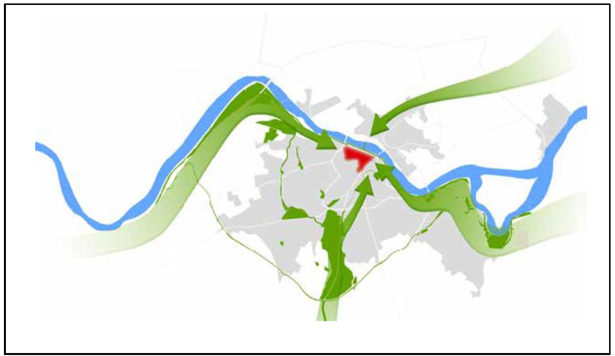
Figure 3.8 Wide Open Space, Recreation and Greenbelt Strategy Concept Map
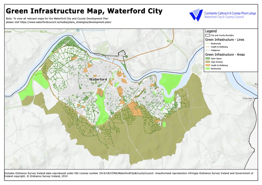
Figure 3.9 Green Infrastructure Map, Waterford City
Taking the initial steps towards developing this Strategy, the Development Plan has identified extensive lands for amenity use. These include inter alia along the Waterford Greenway linking Mt. Congreve to Bilberry with potential for significant biodiversity gain, along the R710 Cumann na mBan linking Waterford Greenway at Carriganore to the Kings Channel area and all intervening amenity areas (including future Greenway to Tramore), enhanced access to Kilbarry Nature Park from Kilbarry, an extension of Waterford Nature Park to border the emerging City South West neighbourhood at Kilbarry and Ballybeg, areas located along the riverside walkway linking Blenheim to the city centre and linking Rice Bridge to our administrative boundary with Kilkenny at Abbeylands, lands along the upper portion of Bilberry overlooking the river, pocket parks along Carrickphierish Road, the South Quays, grounds of St. Otteran’s and St. Johns.
In addition, green and blue infrastructure or Nature Based Solutions have considerable potential to play a role in the sustainable development of the City and it is important to consider that the better integration of biodiversity into economic and development decisions will ensure enhanced outcomes from projects and will mitigate against unforeseen negative consequences of climate change.
In support of MASP Policy Objective 21, we will prepare a Metropolitan Wide-Open Space and Greenbelt Strategy during the initial lifetime of the Development Plan. This will involve collaboration within departments within Waterford City & County Council and collaboration with key stakeholders such as Irish Water, NPWS, OPW, SRA, SETU, Wexford Co. Co. and Kilkenny Co. Co. and the integration of a number of key elements already mentioned above while also considering the future economic and recreational function of Waterford Harbour and the River Suir through the preparation of a Strategic Integrated Framework Plan for the Harbour, having due regard to our obligations in terms of the Habitats and Water Framework Directives.
|
Citywide Amenity/ Recreation and Blue Green Infrastructure Strategy Policy Objective |
|
|---|---|
|
W City 20 |
In support of MASP Policy Objective 21 and delivery a more climate resilient and sustainable city and metropolitan area for the county and region, we will prepare a Metropolitan Wide-Open Space and Greenbelt Strategy during the initial lifetime of the Development Plan in collaboration with key stakeholders such as Irish Water, NPWS, OPW, SRA, SETU, Wexford Co. Co. and Kilkenny Co. Co. This will include a Blue Green Infrastructure Strategy for the City. This will also identify a location for a Regional Scale Park within the Waterford Metropolitan Area as well as the development of neighbourhood parks and open spaces’ in a manner consistent with Waterford MASP Policy Objective (PO) 21 (c) as identified in the RSES. |
3.9 Waterford City Decarbonising Zone
While the Development Plan has set out a number of climate change policy objectives which incorporate our Climate Adaptation Strategy and policy objectives to guide Waterford towards a more climate resilient low carbon city and county, our obligations under the National Climate Action Plan has identified a number of specific actions to be undertaken to assist in our just transition. In particular Action 165 specifically requires identification of one location or area in each local authority that would be subject to a plan for a Decarbonising Zone (DZ). These are defined as spatial area in which a range of climate mitigation, adaptation and biodiversity measures and action owners are identified to address local low carbon energy, greenhouse gas emissions and climate needs to contribute to national climate action targets.
Plans for the identified DZ should also consider the economic and social benefits of decarbonising including just transition and health. The principal projects and actions required to deliver the Decarbonising Zone include:
- Electricity sourcing.
- Heat management.
- Reducing needs for travel and shifting travel modes towards active and public transport.
- Enhanced building energy efficiency.
- Carbon sequestration; and
- Energy storage and management systems.
In addition the associated benefits aligned to the above relate to benefits of improved air quality, health, biodiversity, embodied carbon, agricultural practices, sustainable land management, lower noise levels, waste, water, circular economy etc., and should integrate with smart data and ‘smart cities’ initiatives (as relevant). The Development Plan has prepared the way for the DZ in terms of its core strategy and policies relating to renewable energy, climate change, active travel, placemaking, amenity/open space and Blue Green Infrastructure. It is envisaged that lessons learned in the DZ can be applied universally across our administrative area and beyond.
Waterford City, in its role as the Regional Capital and regional driver of employment and population growth is ideally placed to play a significant role in decoupling our economic growth from that of our carbon emissions. Waterford City and County Council will commit to meeting an average 7% per annum reduction in overall CO2 emissions from 2021 to 2030 (a 51% reduction over the decade) within the DZ. The implementation of this DZ reduction targets by 2030 is the first phase for “Waterford City in achieving carbon neutrality by 2040”.
As a first step we will develop a Spatial Energy Demand Analysis (SEDA) under the guidance of the Department of Housing, Local Government and Heritage (DHLGH) together with a comprehensive DZ Implementation Plan by the 31stDecember 2021 and set up a dedicated DZ Office to develop and implement the Waterford 2030 Decarbonising Zone Plan and to work towards a Carbon Neutral Waterford by 2040.
|
Waterford Decarbonising Zone Policy Objective |
|
|---|---|
|
W City 21 |
In order to ensure Waterford City fulfils its role as the Regional Capital and regional driver of change in terms of economic and population growth in a manner that is sustainable in terms of reducing our carbon emissions in line with our international targets, we will collaborate with key stakeholders such as CARO, SEAI, EPA, DECC, SETU, Kilkenny Co. Co., the SRA, NTA and other business operators and representative groups such as Waterford Chamber to fully devise and implement actions to achieve the Waterford City Decarbonising Zone. We will support and facilitate projects which contribute towards achieving the carbon emission reduction targets. |
3.10 Waterford City and MASP Policy Objectives
|
Waterford City and MASP Policy Objectives |
|
|---|---|
|
W City 22 |
MASP Implementation Plan for, and deliver, the concentric city envisaged in the Waterford PLUTS and Waterford City MASP, as a leading member of the MASP implementation body, in collaboration with the Southern Regional Assembly, Kilkenny County Council, and other principle stakeholders with regard to governance and implementation, service and infrastructure delivery. |
|
W City 23 |
New Sustainable Neighbourhoods We will promote and support consolidation of Waterford City in two new neighbourhoods as identified in the RSES i.e. City South West Neighbourhood (University/ Ballybeg/ Kilbarry/ Lacken), and City North West Neighbourhood (Carrickphierish/ Gracedieu), in a manner that implements the place making strategy and housing strategy of the Development Plan, and supports the role of Waterford City as an international location of scale, and a primary driver of economic and population growth in the Southern Region. |
|
W City 24 |
The Regional Capital Utilise the opportunities and strengths of Waterford City and its key growth enablers, in order to secure a city of scale to drive broader regional economic growth, and to further develop a vital and vibrant city core which facilitates an appropriate mix of commercial, heritage, cultural, riverside, and residential uses. |
|
W City 25 |
Transformational Change We will implement the Development Plan strategies and policy objectives over the period to 2028 to deliver transformational change across Waterford City consistent with the NPF, SRES and MASP. To this end we will seek associated investment through the National Development Plan, the Urban Regeneration Development Fund and other available funding mechanisms. |
|
W City 26 |
The Rural MASP Area In the rural area of Waterford MASP we will ensure:
|
|
W City 27 |
Critical Transport and Mobility Infrastructure We will ensure that the growth of the city takes place in an infrastructure led manner that is Transport-Orientated and sustainable in terms of integrated land use and transportation planning, and which reduces congestion, air pollution and enhances the quality of the urban environment. To inform our future decision making in this regard we will review PLUTS during the lifetime of the Development Plan on the completion of WMATS and its associated demand management study. This process will identify a number of new objectives; however, in the interim a number of objectives include inter alia:
In addition, we support the development of transformational infrastructure such as an additional city centre river crossing, a down-stream river crossing and an outer orbital route which will enable the concentric city to develop and the city centre to be fully reconfigured to cater for the needs of its visitors, residents and business community. Indicative locations and routes for these infrastructural elements will be finalised during the life of the Development Plan. Proposals for development shall ensure no adverse impacts on the integrity of the River Suir SAC. |
|
W City 28 |
City Neighbourhood Strategy We will continue to implement the Neighbourhood Strategy in order to provide for the development of sustainable, inclusive and diverse neighbourhoods, focused on neighbourhood/ district commercial centres with a mix of uses, densities, community facilities and neighbourhood centre uses. Furthermore, we will implement measures to enhance permeability within and between neighbourhoods to deliver the 10-minute neighbourhood concept through active travel modes. |
|
W City 29 |
City Suburbs To retain, protect and improve the environmental qualities of the existing suburban areas; to reinforce their neighbourhood/district commercial centres and to provide for additional community youth and public services, amenities and facilities as required. |
|
W City 30 |
South Quays Design Framework During the lifetime of the Development Plan we will prepare a Design Framework for the South Quays. This will be dominated by public amenity and biodiversity spaces building on the imminent Waterford Greenway and Waterford to New Ross Greenway interconnection and be interspersed with commercial uses which respect the built form and historic fabric of the South Quays while interfacing with new development of scale on the North Quays. |
|
W City 31 |
Ferrybank Collaboration While we recognise the independence of statutory planning in the Ferrybank area of South Kilkenny as expressed in the Ferrybank and Belview Local Area Plan 2018, we will collaborate with Kilkenny County Council and other key stakeholders in order to implement priority actions to deliver the shared vision, to achieve a concentric city and the enhancement of all our communities and neighbourhoods. |
[1] The growth scenario envisaged by PLUTS included a population growth of 30,000 and an additional 12,800 jobs.
[2] Sites with potential to accommodate taller buildings (Above 4 floors in height) and higher densities are identified by a green highlight.
[3] Zone 1 includes the following streets: Michael Street, Broad Street, Barronstrand Street, Great George’s Street, Blackfriars Street, Arundel Lane, Arundel Square and Peter’s Street.